GWYDIR VALLEY IRRIGATORS ASSOCIATION
Floodplain Flow And Licensing
.png)
GWYDIR VALLEY IRRIGATORS ASSOCIATION
The NSW Water and NSW Environment Ministers agreed to amendments to the water sharing plans in the Gwydir Valley to enable
floodplain harvesting licences. These new rules were gazetted on 29th July 2022 and licences are to be active from at least 1 September
2022. The new rules outline metering and reporting requirements, legal limit compliance for NSW and Commonwealth legislation, trade
restrictions, limitations on new works and access rules during droughts. For more information on the rules see our webpage 'New
Water Sharing Plans for the Gwydir Valley'.
The NSW Government gazetted regulations to enable the determination, calculation, measurement and implementation of replacement floodplain
harvesting licenses in NSW. These regulations formalise the ability for NSW to manage floodplain harvesting and improve how NSW
manage water take by irrigators to legal limits imposed through NSW and Commonwealth legislation.
The regulations were separated for licensing and the measurement component, which includes the temporary exemption to collect rainfall runoff when it is not flooding as per best management practice guidelines and environmental safeguards.
Some minor amendments were made to these regulations due to drafting errors and a need to better align the agreed Measurement Policy with the regulations. These can be explained by the Department of Planning and Environment - Water here.
The NSW Legislative Council Select Committee Inquiry into how floodplain harvesting will be licensed in line with legal requirements of NSW Water Management Act and the Murray Darling Basin Plan handed down its final report, including two dissenting reports. The NSW Government responded in May 2022. All the reports are available here.
The release of the consultation outcomes report provides a clearer indication on compliance proposal but also the work program NSW Government has taken to address some of the aspects raised during the consultation period.
This 'Floodplain Harvesting Licensing in the Gwydir Valley' fact sheet has been prepared to reflect the decisions contained within the consultation report on how the compliance approach works.
What does licensing mean?
Having floodplain harvesting and/or overland flow take, is an important source of water for many water users, available when our rivers and creeks are full and spilling onto floodplains. Licensing will mean that water will be limited, managed by account rules, metered and accounted for against individual accounts and valley-wide legal limits. Currently this is not the case, this form of take is considered an estimated interception much like hillside farm dams.
Licensing in the Gwydir Valley will mean access to this form of water will be reduced from 30% of historical long-term volume of water diverted for irrigation down to 23%.
Noting that diversions (including floodplain harvesting) account about a third of long-term total gauged system inflows. Total volume of water on a floodplain are not well understood as yet, so a measure of river flows is only possible.
How does it achieve legal limits?
The compliance strategy is multi-faceted but creates a smaller accessible bucket than what is currently available, over the long-term.
This includes issuing unit shares for floodplain harvesting of which are 21.5% lower than current long-term
average take. These
shares equate to 20% of the total on-farm storage in the valley, meaning that if a water user was to fill these storages
in a flood, they would need to accrue water and not access FPH for five years or must utilise their other forms of take, all of which are
also limited. This means that even if water user carryovers up to their maximum 500% accrued over five-years, total licensed take is 27%
smaller than the current maximum volume
modelled to be accessed during a wet sequence.
What the March 2021 flood in the Gwydir told us
Widespread whole of valley flooding occurred in March 2021 in the Gwydir (and MacIntyre Rivers) this resulted in full supplementary allocations, floodplain harvesting opportunity and full, free flowing rivers and streams which meant Menindee Lakes filled.
If licenses existed for the next flood, take would be 50-70% of what was estimated in March 2021 because of new account limits and rules. Even with transitional account balances using a modelled starting volume, the average reduction of water that could be taken is 22%.
This event could be measured using the proposed frameworks for floodplain harvesting measurement and rainfall runoff exemption. Many water users voluntarily measured. The NSW Government also undertook satelited analysis as they have previously applied.
However, one gap in measurement is calculating in near real time the volume of water on the floodplain. Measuring water flow and volumes in a rivers, streams and creeks is only one part of the valley water balance in times of flood when water is spilling out from these systems. This measurement of water on the floodplain should be improved for transparency.
What is the consequence of the reductions?
Reduced water for irrigation will have a direct flow on to the community we know every $1 lost at the farm gate will take a minimum of $2.18 from our economy, it means less money to spend in shops and businesses, less jobs and less families and less services in our community. An estimated on average loss of $92M[1] of economic activity transferred to environmental benefits within our own valley. The impact of this will be greater in the first years of implementation given the NSW Government is not proposing transitional arrangements for accounts with the new reforms.
Less diversions will lead to a 13% increase in mean annual flood volumes largely within the valley as the Gwydir historically is a closed system with limited river connectivity and floodwater remains in our wetlands. The internationally important Gwydir Wetlands are expected to significantly benefit with modelled environmental water needs for native vegetation, native fish and waterbirds being met more often by an average of 82%, 97% and 142% respectively.
Contrary to opinion, modelling indicates if you removed floodplain harvesting entirely you would not impact Lower Darling or southern allocations by any more than 1%. For more information on these many mistruths, see our page 'Addressing Mistruths'.
On 6 May 2021, the NSW Legislative Council (Upper House) disallowed the Governments proposed framework to license, meter and manage floodplain harvesting in NSW. Meaning there is no regulatory framework in place to enable the licensing of floodplain harvesting take in NSW.
The disallowance on 22 September 2020 by the NSW Legislative Council (Upper House) rescinded the NSW Government’s Water Management (General) Amendment (Exemptions for Floodplain Harvesting) Regulation 2020 the “exemption” on water users needing to hold a water licence to utilise their approved floodplain works as of 3 July 2008 (eligible floodplain harvesting works), to collect overland flow.
The disallowance:
More information is available on our update What's the hype about the fph disallowance mean
The NSW Upper House inquiry as well as ongoing media and social media commentary has presented many claims regarding floodplain harvesting suggesting volumes in any one year, potentially volumes in a flood or over the long-term. In the absence of substantiated facts these claims are opinion and will remain that until the NSW Healthy Floodplains project is finalised and volumetric monitoring begins.
Good information, informs good debate.
We've provided a number of responses to media and other commentary as well as, ensure this website it up to date with the facts and as a result have had to collated this on our page Addressing Mistruths.
We have collated a list of claims in specific articles and responses to these claims in the following document from 2019 and more recently, claims made during recent parliamentary debate from 2020.
There is also this statement regarding recent flooding in the Gwydir and Namoi Valleys here following floodplain in 2020.
The requirement to establish volumetric licences for floodplain harvesting does not create new water.
This is legitimate historical access being bought into the current regulatory framework by converting a descriptive take under NSW Water Act 1912 into a volumetric license consistent with the NSW Water Management Act 2000.
With all water available to irrigators limited, future licensing of floodplain flows will provide tools to better measure and monitor take to ensure overall usage remains within limits, as set out in water sharing plans and the Basin Plan.
While the issuing of licences for historical forms of take is not without its challenges, as irrigators will be subjected to further regulation and costs, it will include the following benefits:
We have supported implementation and are seeking finalisation as part of water resource planning because of these outcomes but also to better align the security of this water right with other entitlements already within the current regulatory framework as a means to maintain the future of the industry and economic activity in our region.
Traditionally, floodplain or overland flow occurs when water spills out from rivers or stream and flows across a landscape, often regarded as the floodplain where this can typically occur. As the name suggests, a flood event of some scale must occur to take water off the floodplain.
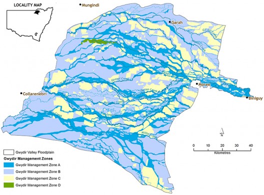
The Gwydir Valley is a large inland delta that expands in a westerly direction from the Newell Highway, with most flows from the Gwydir River historically flowing towards the Gwydir Wetlands. The NSW Government declared the Gwydir Floodplain in the Floodplain Management Plan for the Gwydir Floodplain in 2016 which is presented below.
The Water Management Act 2000 now describes overland flow as both floodwater and also stormwater or rainfall run-off. This has not
traditionally been a description of floodplain harvesting in NSW. It means any irrigator with capacity to intercept and store
rainfall run-off under this definition, could also be described as a floodplain harvester. Despite the fact rainfall run-off within
irrigation fields is often enhanced through design and management, is likely to be used agricultural water and maybe potentially
contaminated.
Nonetheless, the floodplain harvesting policy includes rainfall and therefore, has state-wide application. A consistent framework that ensures all NSW water users can meet each of the legislative and regulatory requirements, when operating their farms, is important. The Department have prepared this YouTube video to explain.
Irrigators in our region have been legitimately accessing overbank flows since irrigation development, when they constructed flood protection works for fields and property and then intercepted some of this excluded water. This form of access is not new. Any entitlement and subsequent allocations provided through the implementation of licenses are already estimated as historical take, the licensing process is better estimating this take .
The NSW Government is required by national agreement to bring this legitimate form of access, originally described and licensed under the NSW Water Act 1912, into the current licensing framework of the NSW Water Management Act 2000. Undertaking this ensures consistency with national reform programs like the National Water Initiative signed in 2004 (see A History of Water Reform) and the Murray Darling Basin Plan 2012 (see Key Legislation) as well as protect outcomes under the Basin Plan and provide NSW better tools to regulate, share and account for water take in the valley.
The Commonwealth Government provided funding to expedite the NSW and Queensland governments obligations. The NSW government called the project, the Healthy Floodplains program and they have provided this current fact sheet on the implementation of the project.
The NSW Government is also responsible for managing all water take within limits, therefore they must ensure that there is not any future growth in any form of access including floodplain. Transitioning this access into the current framework will provide better tools to help NSW achieve this, including providing users security of access through restricting industry access to a historical level of take to industry, monitoring that and restricting future growth, which will maintain or improve floodplain flows downstream, including to any environmental assets.
Growth will be monitored and limited via a three-fold compliance approach rather than the two tools available today, including:
This form of access is not new. Determination of licenses will be based on updated valley hydrology model, re-designed and re-built to better represent all water in regions rather than the previous focus on in-river flows.
Licences and shares are determined with two key inputs:
Water made available to irrigators must be within valley-wide regulatory limits imposed firstly by the Murray Darling Basin Ministerial Cap in 1994, the relevant NSW Water Sharing Plan - Plan Limit (for Gwydir set in 2004 and updated in 2016) and the Sustainable Diversion Limit in the Murray Darling Basin Plan (referenced at 2009 and legislated in 2012). The historical take has already been included throughout these process, although the improvement in model estimates may result in improved estimates of take across these key reform dates. This is explained by the Murray Darling Basin Authority who state:
"Changes to the limits do not mean more water is available for use, this water is being used already or is available for use—it is just bringing this use into the new system, ensuring it can be monitored, and use does not grow over time beyond these limits." via their website Current Diversion Limits for the Basin.
More information is available at A History of Water Reform.
The management of floodplain take is via the floodplain works approval process and therefore, focus on the structures within the floodplain. Upon implementation of the healthy floodplains project the NSW Government intends to continue to monitor floodplain structures, via individual works infrastructure plans whilst also monitoring the individual and valley take volumetrically.
The NSW Government have recently announced the NSW Floodplain Harvesting Measurement Policy (2020), after consultation on multiple iterations of the draft monitoring and auditing strategy. Essentially the NSW Government will require landholders receiving a floodplain harvesting access licence to contract a duly qualified person to install telemetry-enabled storage meters that meet the Minister’s minimum specifications outlined in the policy.
The policy outlines a staged implementation approach being:
Because floodplain harvesting is a unique form of take; it is site specific in terms of capacity (infrastructure) and opportunity (flood events), highly episodic and therefore variable on temporal and spatial scales it will require a unique monitoring solution. NSW has also announced that for those farms who do not fall within the default approach, they can have their alternative methods assessed by a Measurement Technical Panel to ensure the measurement objectives are still maintained.
We fully support a robust strategy that is achievable for both government and water users and benefits everyone. It’s important we can measure and account for overland flow like all other forms of water and the most practical and effective approach is via storage devices, as all water on a farm ends up here regardless of how it intercepted.
The final policy appears repeatable, auditable and can be verified by the regulator, its cost-effective and fit-for-purpose, just as we recommended.
We commit to fast-tracking the achievement of those measurement requirements provided there is capacity to supply devices and qualified installers.
We commit to implementing the proposed processes and measure and report any FPH using our exiting measurement devices, prior to the implementation of licences and any required new devices.
The measurement and accounting of any water take, should also be subsequently supported by a strong and proactive compliance framework that uses the most current technology. We welcome the NSW Governments trial of technology as part of the first flush monitoring in February 2020 (as reported here).
We support the implementation of a three-fold compliance strategy as part of monitoring floodplain take.
See our joint submission, with other northern irrigator groups on the NSW Draft Monitoring and Audit Strategy for Floodplain Harvesting here.
The NSW Government has produced this brief video explaining the requirements.