The Gwydir Valley Irrigators Association (GVIA) represents in excess of 400 water entitlement holders in the Gwydir Valley.
Our water entitlement holders are some of the most progressive in the world, actively engaged in, and innovating irrigated agriculture. From broadacre crops such as cotton to tree crops such as pecans, oranges and olives, our industry is diverse and productive. We are all acutely aware that reliability of water in the valley is low, and thus strive to Make Every Drop Count for the producer, the community and the environment.
Our vision is for the local irrigation industry, the environment and the Gwydir Valley community to have a secure, vibrant future, with the GVIA recognised as an industry leader.
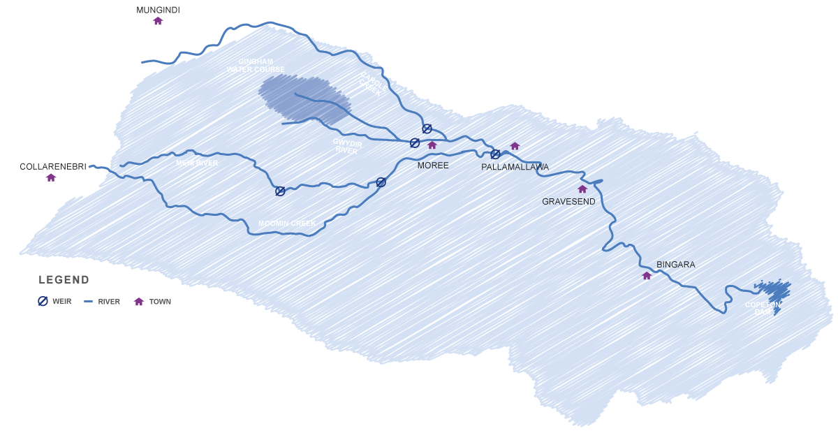
The Gwydir Valley, centred around the town of Moree in north west NSW is an extremely productive agricultural region. Agriculture employs 20-30% of the population and contributes an estimate 7.8% of NSW’s total agricultural production. Irrigated agriculture is particularly important, contributing significantly to the social and economic wellbeing of the region.
The irrigated olive industry was initiated in the Gwydir Valley over 25 years ago. Olives are a vertically integrated industry
with the nationally recognised Gwydir Grove Olives the largest local producer and processor. In recent years the number of olive
trees has declined as some producers have switched from olives into pecans.
Oranges are a new irrigation industry in the Gwydir Valley, with the majority of the trees planted since 2005. It is currently expanding
with an expected area of 350Ha to be under production by 2020. The citrus industry in the Gwydir Valley is part of the locally owned and vertically
integrated Grove Juice business.
The pecan industry is an important irrigation industry for the Gwydir Valley. Trawalla, owned and operated by Stahmann Farms is the largest
in the region producing approximately 90% of Australia’s pecans. Australia is the fourth largest global producer of pecans. Stahmann Farms operate
the country's only commercial pecan shelling, value-adding and packing plant.
The Gwydir Valley is a diverse broadacre cropping region producing a range of both summer and winter crops. The primary winter crops include; chickpeas,
wheat, barley, and more recently canola. While summer plantings include sorghum, faba beans, mung beans, maize and sunflowers. The majority of the broadacre
cropping area is dryland.
Cotton is the most significant irrigated crop in the Gwydir Valley with an average of 70,000Ha. It is also an important dryland crop with an average of 79,000Ha annually.
The area planted can fluctuate from year to year, being dependant on either available irrigation water and seasonal rainfall.
Lucerne and Hay are niche crops in the Gwydir Valley covering an estimated 4,500Ha. Lucerne is produced primarily on smaller blocks and is irrigated by bore water
entitlements. Hay production includes Lucerne, cereals and pastures.
The turf industry has been a part of the irrigation industry of the Gwydir Valley for almost 20 years, but there are only two producers in the valley. It covers a very small
area of only 20Ha and is irrigated by bore water entitlements. The primary species produced is Buffalo.
The Gwydir Wetlands are a system of terminal delta wetlands, located downstream of the Gwydir River approximately 45kms west of Moree in north west NSW. They are recognised for their
unique vegetation and bird breeding potential. The wetlands are estimated to consist of approximately 6,829Ha of semi-permanent wetland and 77,949Ha of floodplain wetland.
WaterNSW monitor 51 river gauge locations in the Gwydir River and streams(418) using telemetry with data accessible in real time. These sites collect a range of information from flow rate,
discharge volume and river heights and assist WaterNSW in their role of water delivery operators whilst providing an indication of water availability.
All water in the Gwydir is managed by water sharing plans established progressively since 2004. Currently 19% of long term Gwydir river flows and 85% of sustainable yield of the Lower Gwydir
aquifer are available for irrigation. This has been reduced over time following reforms and water recovery for environment.
The are a number of groundwater sources including the Lower Gwydir aquifer used for irrigation and the Great Artesian Basin, including recharge zones. WaterNSW monitor
levels via 26 monitoring sites with data accessible in real time.
Groundwater provides reliable irrigation water, quality drinking water for towns and properties and is one of the region’s major tourism attractions.
Copeton Dam is located on the Gwydir River upstream of Bingara on the north-west slopes of NSW. It is one of the largest inland dams in NSW with a capacity of 1,364,000
megalitres of water. It was initiated in 1966 to provide town water supplies and to boost irrigated agricultural production in the Gwydir Valley.
Copeton Dam is at 40% and steady and as a result, general security allocations have increased by 39.12% resulting in 54.8% allocation for
the year for environmental and production. Most of this water will be carried over to be used at a later time.
Full supplementary allocations were also made available with up to 116,000 ML ordered by irrigators and 5,700 ML by environmental water
holders during these events.
WaterNSW have initiated flood forecasting and reporting following the recent widespread rain and flooding in the Gwydir, Border Rivers,
Macquarie and Culgoa. This replicates and updates their reporting during the First Flush event in 2020. The most
recent update on 6
April revealed between 400-600GL to flow into Menindee Lakes from all the tributaries. However, forecasting is limited due to the nature of
the floodplain flows and natural breakouts along the Barwon River.
Its great to see so many rivers full and spilling.
How the water is managed once it reaches Menindee Lakes will be closely scrutinised given the likely volumes and the many competing
interests there. The NSW Water Minister recently said "NSW will be making decisions on how to manage the inflows into the
Menindee System with the first objective being to improve water supplies in the Lower Darling coimmunities and ensure the top two Lakes are
filled" via The Land ift.tt/3wybHSV.
The peak of the floods in the Gwydir Valley have passed through the township of Moree and are heading west. Many describe this event as
being two floods, the one caused initially from local rainfall of between 100-200mm and then the flood from upstream water sources like the
Horton River into the Gwydir and Mehi systems, that came at least three-days later.
Local rainfall and unregulated water is therefore, now being backed up by the major floodwaters from upstream, which is likely to result in
sustained, major flooding in the lower sections of the Gwydir floodplain.
All the rivers and creeks in the lower floodplain are flowing above capacity as water spills out. There is 100% supplementary access
available. During this time, Copeton Dam has increased from 22% to 39% capacity during this event, with a resource allocation likely
in early April in response.
There is a history of flooding in the Gwydir Valley and the peak height of the flood in Moree and surrounding gauges is provided on our
page 'History of Flooding' and compared with previous large and major floods.
Also, we encourage you to fill out the Natural Disaster Damage Survey https://fal.cn/3ecfO.
The survey is for NSW DPI and Local
Land Services NSW
staff, farmers and agricultural industry representatives can use to record damage to primary production and animals from natural disasters.
Read More
The Bureau of Meteorology have issued the first MAJOR Flood Warning for the Gwydir Valley with a peak today in the afternoon. Local
rainfall and inflows may mean this peak is earlier.
The Gwydir Valley is a distributary river system, which spreads our rivers and creeks across the Gwydir Floodplain which acts as a large
inland delta. Our rivers spill out naturally to these floodplains when they are full and spilling. Not every flood is the same, they
range in magnitude of height and duration and can occur from locally generated rain or from rainfall further upstream of the
catchment.
Recent flood warnings in December 2020 were predicted because of upstream rainfall and inflows. This was a short, sharp and small flow
which has created limited flooding. For example, the height at Pallamallawa was half of that experienced in 2011 and 2012 when the
entire north-west was in flood. This flow also didn't contain a lot of water but its peak flow rate at Pallamallawa of 33,000 ML/day was
still higher than the operating capacity of the regulator and cannot be managed. Rather this water flows naturally, unmanaged by
WaterNSW to the watercourse the lowest point of our inland delta and towards the Gwydir Wetlands.